
It was a gray and rainy Sunday with a pervasive chill that seemed to deny the impending change of season. I should have gone down to the garage and sorted through some stuff, but they said the cold rain would continue all through the day.
The Russians had mentioned the possibility of going to the Raven’s Nest for coffee and quiche, so I did not cook breakfast as I normally do, and plowed through the email on the only irritatingly slow internet, listening to satellite radio at a house-filling volume that wasn’t blasting, but still way too loud for communal living at Big Pink.
It got toward noon as I pecked on the computer and did some indoor chores with the vacuum and did a load of laundry and wiped down all the counters. I looked at the clock. Too early to start drinking, and no further tasks I wanted to start, so I locked the place up and drove the Panzer next door to pay a short call on the Russians and add my voice to the campaign to discourage the American daughter NOT to deploy to Afghanistan.
I was assailed by a wonderful blue-eyed Husky and Biscuit-the-Wonder-Spaniel who seemed happy to see a fresh face.
“The end of wars never go the way one hopes,” I said. “And you do not need to go and see the Elephant in person. They do not call it Danger Pay for nothing.” The American daughter nodded gravely- she is a stubborn woman, and I hope Mattsky and Natasha do not have to worry through a long deployment in a war that will not end well.
Then I drove south. I had been invited to meet up with some Lake Ana-based pals the night before, but demurred at the time due to my state of intoxication and the impending arrival of the dark. “We can do brunch some time,” I said. “I trust myself to have a couple drinks, or to drive at night, but drinking and night driving are not wise.”
In daylight, I thought I might motor down to Mineral, a little town about 22 miles south of Refuge Farm on Route 522, the Zachary Taylor Highway. It is a nice and placid rural road named for the 12th President who hailed from Orange County where part of the road meanders.
Zach was the second President to die in office, second to last Whig, and the last President to own slaves as the Chief Executive. I had to chew on that last bit- it is something that I consider sometimes driving in the Virginia countryside.
There is only one stoplight in all the distance from Culpeper, which was the heart of the Old Dominion’s gold mining back in the day. I stopped for gas at the junction where Route 20 crosses the road. Zach’s road is good asphalt, but cuts through rolling terrain that is marvelously unforgiving if you left the road and had to try the ditch. It is pretty horse-and-beef country, rich soil, good grass and crumbling old houses, some of which remember clearly the Yankee invasion.
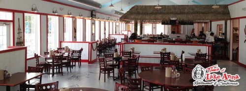
(Tim’s is modern and not rough. It is ready to party this summer. Photo Tim’s).
I saw Tim’s, the bar to which I had been invited the night before. It is no dive, as I had assumed. It is a new-start resort complex on the north tip of Lake Ana, a man-made reservoir that is unconnected to the history of the area.
The reservoir was formed by the North Anna Dam, constructed in the late 1960s to provide a cooling pond for the North Ana Nuclear Generating Station. By 1972 Dominion power had cleared all the timber from the prospective lake-bottom and the dam was almost complete. The engineers estimated that it would take three years to fill the valleys, but Hurricane Agnes helped out and the lake was full in a year and a half.
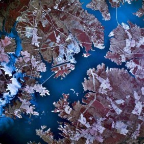
(Lake Ana today. Photo Wikipedia).
It is now the third largest lake in the state, and being located in a general triangle between Richmond, Charlottesville and the sprawl of Northern Virginia, is a popular recreational and retirement destination.
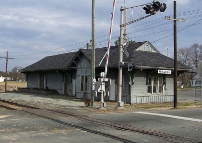
I did not stop, though I could have, and instead pushed on to Mineral, about five miles south of the only causeway across the lake.
The last time the town was in the news it was as the epicenter of our Virginia earthquake two years ago, which actually made one of my pictures at the farm go crooked, and as far away as my office made the glass curtain-walls of the building across the street shimmer in motion.
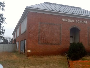
(The Mineral School was one of the casualties of the 2011 Quake. Photo Socotra).
No earthquake today. There is another bar/restaurant down in Mineral that sounds like a good day trip, and a cute little barbecue place on main street, which is has lost a few structures but is otherwise is a state of graceful decline, like the Mineral School:
Mineral was originally called Tolersville Station (though the post office opened as Tolersville in 1837). In 1838, the Louisa Railroad constructed the Rough and Ready Turnout near Toler’s Tavern to service the Rough and Ready Iron Furnace. The Rough and Ready Furnace remained in operation until about 1860 when the war stopped economic activity, and the name of the town was changed later to “Mineral” in honor of the local deposits of copper, gold, mica, and sulphur.
At its peak, Virginia was the third largest producer of gold in the nation. Near the end of the Civil War, the Union troops began a systematic campaign to destroy the industrial base of Virginia, and the gold mines and furnaces of Mineral were among their targets.
There are almost 500 citizens of Mineral, and they are hanging on with tourism and agriculture.
Then there was the quake in August of 2011. No one died, but the 5.8 magnitude earthquake was centered 5 miles (8 kilometers) south-southwest of town, centered at a depth of 3.7 miles below the placid rolling hills. The roof of Mineral’s town hall collapsed, and three of the six schools in the county’s school system suffered heavy damage. There were no fatalities, thank God.
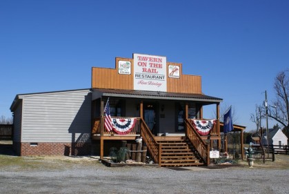
I poked around and took some pictures. With the rise of Lake Ana, there are all sorts of bed and breakfast places on the old plantation, and many wineries that beckon for tasting. If I had some company, I would have stopped at the funky Tavern on the Rail, a decent country restaurant, but instead, I decided to head back north.
I backtracked on 522 to 208, the Courthouse Parkway, which takes the only causeway across the lake north and west to hit the interstate to head back north to Washington. More structures and things of interest; old stores no longer stores from the first age of motoring, collapsing barns, and the three locations of the Spotsylvania Court House, contested so violently in the Late Unpleasantness between the States.
You cannot get away from the war in northern Virginia. All the fury was concentrated right here, and the wounds may have healed, but the scars remain. Much more powerful than that earthquake.
There are a lot of roads to travel from Refuge Farm, and I intend to do so, soon. It is a rough and ready region, and spring is coming, ready or not.
Copyright 2013 Vic Socotra
www.vicsocotra.comRenee Lasche Colorado springs